| << Chapter < Page | Chapter >> Page > |
You have learnt that prevailing weather conditions form the climate of a particular place over a period of time (20 – 35 years). As the weather is unpredictable, we are not able to say for sure that it will rain in Cape Town on New Year’s Day, but we do know that Cape Town will normally be drier at this time of the year than in June. Climatic conditions over a long period of time have shown that Cape Town receives most of its rain during the winter.
When we study the features of the types of climate that prevail in places, it is clear that large areas experience the same average conditions and that a type of climatic region is therefore formed. Through the ages people have often been influenced by the climate when they must to decide where they want to settle. Large parts of the earth are either too cold, or dry or hot for people to live. The availability of sources also influences peoples’ choice of a place to live. That is why approximately six milliard people on earth occupy only 15% of the earth’s surface.
1. Factors that influence climate
Latitude of a place
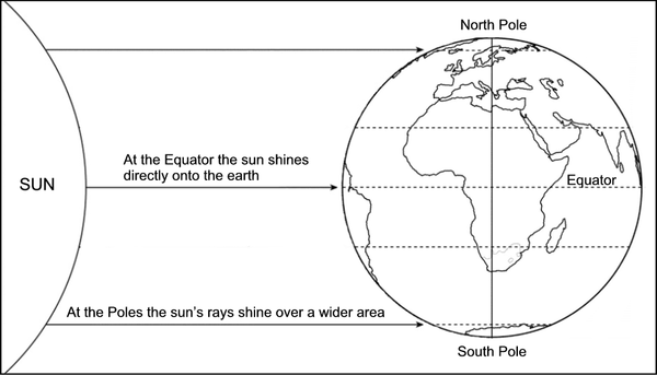
The hottest climates are usually in places closest to the Equator. The further we move from the Equator, the colder it becomes. At 12:00 the sun is directly overhead on the Equator. The rays of the sun are more concentrated and the temperatures rise higher. Further north and south the rays of the sun fall at an angle and are spread over a larger area by the earth’s rounded shape. That is why the sun’s rays are less concentrated and as a result the temperatures are cooler.

At the equator the sun’s rays are almost directly overhead.
At the poles the sun islower on the horizon.
At the Equator high temperatures cause high evaporation, which causes a higher downpour.
Altitude above sea level
The earth absorbs the sun’s rays, converts them to heat and radiates them again. The closer we are to the source of radiation, the hotter it is, and the further we are from the source (e.g. on top of a mountain), the colder it becomes. We can experience the principle of radiation by holding our hands close to a fire (or heater) and then move them away gradually. It becomes colder the further we move away from the source.
It is always cold on top of high mountains. The highest mountain peaks on the earth are always covered with snow.
Use your atlas to find out:
Influence of ocean currents/oceans
The temperatures of the oceans influence the land temperatures. Winds blow the hot or cold air above the hot or cold ocean towards the land and increase or reduce the land temperatures. There are also winds that blow north and southwards from the Polar Regions bringing cold air onto the land.

Notification Switch
Would you like to follow the 'Geography grade 6' conversation and receive update notifications?